Ferrovie dello Stato, Italdron Air Service, Cad Connect
Basilica di San Pietro | Città del Vaticano | Italia
Mapping and analyzing St. Peter’s Basilica using digital technologies to ensure its ongoing future monitoring: this project leverages the digital expertise of Italferr, the engineering company of the Ferrovie dello Stato Italiane Group’s Infrastructure Hub, which has enabled the creation of a digital twin of the Vatican Basilica. The study, conducted on behalf of the Fabbrica di San Pietro, began in July and August 2022, during public closing hours, with the initial surveys required to collect over 3.1 terabytes of data.
The survey phase required two months of internal and external surveys using drones and hot air balloons, 15,000 photos for a total of 630 gigapixels, two weeks of point cloud post-processing using multiple computers in parallel, and a further two months of work to develop the BIM information model and Digital Twin. These are the key figures for the launch of a complex project in which high technology and digitalization merge with the art, faith, and culture enshrined in the Vatican Basilica.
To date, the entire dataset is already in the possession of the Fabbrica di San Pietro. The data from the sensors defined in the monitoring project will be incorporated into the Basilica’s Digital Twin. The processing will be made available to the Fabbrica di San Pietro for future maintenance activities serving the Basilica. Using specific calculation algorithms, it will be possible to investigate the structure’s ability to respond to static and dynamic stresses, gain full knowledge of the structural health, and proceed to the design of a permanent structural monitoring system. The potential future applications are numerous.
To support the project, Italferr has partnered with highly qualified companies such as Italdron Air Service Srl, supported by CAD Connect, for field surveys, and Sacertis Ingegneria s.r.l. for the monitoring system design. The project will be presented to the public as soon as the first phase of data processing is completed.
Playbook: ContextCapture, iTwin, ProjectWise
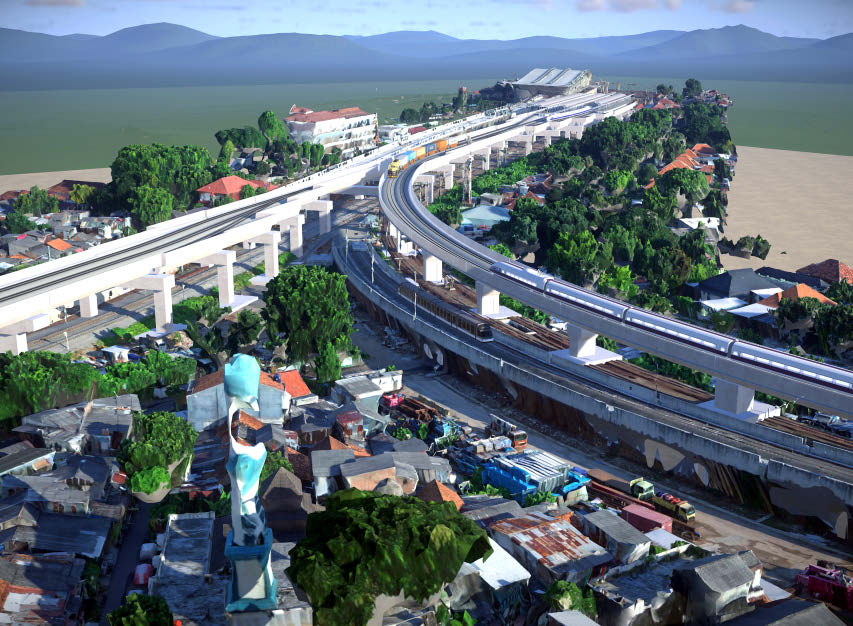 Railway Facility for Manggarai to Jatinegara: Package A – Phase II (Main Line II)
WASKITA Karya (Persero) Tbk | South Jakarta, Jakarta, Indonesia
Jakarta’s Manggarai Station is being converted from a commuter transit station to a long-distance train terminus. With the current single-story station unable to accommodate 100,000 commuters per day, PT. WASKITA Karya (Persero) was selected to build a new bridge connecting the existing first-level mainline track to a new second-level mainline. They were also required to ensure compliance with current industry standards, maintain train operations during construction, and control costs on the prestressed concrete bridge segments, which accounted for 30% of the project budget.
Using OpenRail Designer, OpenBridge Designer, and ContextCapture, PT. WASKITA Karya created a digital twin that incorporated existing site conditions and a federated BIM model of the designed structure, increasing productivity and decision-making. Using OpenBridge Designer, they provided accurate geometry and coordinate information, avoiding miscalculations and reducing the risk of incorrectly ordered segments. Simulating construction sequences in SYNCHRO 4D helped them optimize resources and coordinate delivery.
Playbook: ContextCapture, LumenRT, OpenBridge Designer, OpenRail Designer, OpenRoads Designer, SYNCHRO 4D
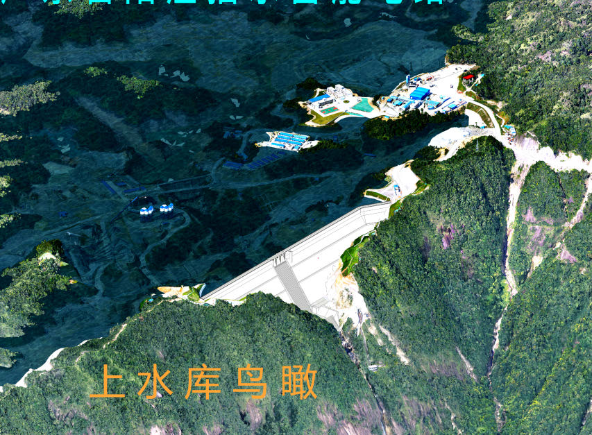 Guangdong Yangjiang Pumped Storage Power Station
Guangdong Hydropower Planning & Design Institute | Yangjiang, Guangdong, Chinaiel, Bern, Switzerland
The Yangjiang Pumped Storage Power Plant has the largest single-machine capacity and the highest net head of all pumped storage hydroelectric systems in China. The Guangdong Hydropower Planning & Design Institute needed to create construction drawings for the facility, located near the Guangdong Yangjiang Nuclear Power Plant. They wanted a short design period, data sharing, and nominal inaccuracies, so they abandoned traditional 2D methods with dispersed data and on-site surveying. Guangdong Hydropower chose to use digital twin technology and 3D modeling for the first time during the design phase.
They executed a collaborative project, using Bentley applications to guide construction, improve safety, and minimize land acquisition. Creating 3D reality models improved design efficiency by 30%, reduced travel costs by 50%, and shortened design time by 800 hours, delivering a digital twin 30 days ahead of schedule.
Playbook: Bentley Raceway and Cable Management, ContextCapture, LumenRT, MicroStation, OpenBuildings, OpenBuildings Designer, OpenPlant, OpenRoads, OpenRoads ConceptStation, OpenUtilities Substation, Pointools, ProjectWise, ProStructures, SYNCHRO 4D
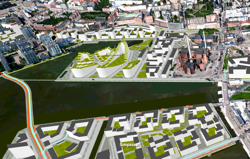 Digital City of Synergy
City of Helsinki | Helsinki, Finland
The Helsinki Digital Synergy project will integrate and leverage existing city models to add more value and support internal processes and public services. The project will also encourage engagement with the general public, improve collaboration, and continue to support strategic goals for a smart and sustainable city. In addition to existing city models, the project involved the Helsinki City Environment Division, responsible for urban planning and development; a 3D team based in the mayor’s office that creates 3D models of the city; and Forum Virium Helsinki, a company focused on smart city solutions. To work together and create a dynamic digital city, they realized they needed an open digital city platform to overcome any technological and collaboration challenges.
The City of Helsinki uses MicroStation, ContextCapture, and OpenCities Map to generate and update a reality mesh and an information model of the 500-square-mile urban area for its digital twin, which includes CityGML. They created a connected data environment using ProjectWise to ensure a single source of truth, with OpenCities Planner serving as a visualization and collaboration platform for all stakeholders, including the public. The open digital solution enables better decision-making by connecting the right information to the right stakeholders and provides a reliable digital data infrastructure to support sustainable smart city initiatives. The City of Helsinki shares the city’s digital data with the public to encourage dialogue and engagement.
Playbook: ContextCapture, LumenRT, MicroStation, OpenCities Map, OpenCities Planner, ProjectWise
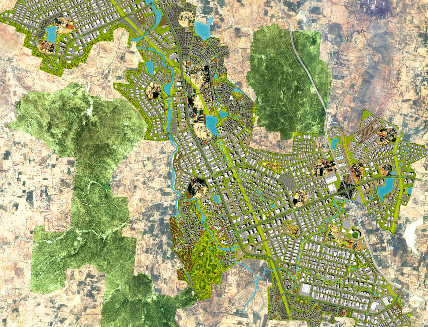
Master Planning & Engineering for Infrastructure Development at Tumakuru, KarnatakaS2 Main Works Civils Contract
Jacobs Engineering India Pvt. Ltd. | Tumakuru, Karnataka, India
Jacobs Engineering was tasked with preparing the master plan and preliminary design report for the INR 85 billion Tumakuru Node development project in Karnataka, India, as an industrial hub focused on advanced sustainable technology. However, they faced topological, technical, engineering, and coordination challenges, compounded by an aggressive schedule. They needed software that would help keep the project on track and ensure accurate information sharing and informed decision-making.
Already familiar with Bentley applications, Jacobs used ContextCapture and LumenRT to develop and visualize an accurate 3D rendering of the entire project to reduce risk, improve decision-making, and speed approvals. They used ProjectWise and iModels to share and review models and information, as well as perform clash detection, to deliver better results on time. Their 3D digital approach saved hours of resources and improved understanding of future development. OpenRoads and OpenFlows have reduced rework and minimized fixes, resulting in time savings of 15% to 20%
Playbook: ContextCapture, LumenRT, OpenFlows SewerGEMS, OpenFlows WaterGEMS, OpenRoads Designer, ProjectWise, STAAD