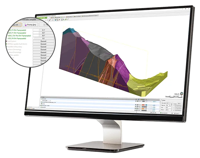
Leapfrog Works
Get underground information with Leapfrog Works
Dynamic 3D geological modeling designed for civil and environmental engineering projects
Categoria/GEOTECNICA
WHAT IS LEAPFROG WORKS?
Leapfrog Works helps you visualize and understand your data so you can communicate risks to stakeholders at all levels of engineering and make better decisions across all your civil engineering and environmental projects.
Save time on analysis
Change the way you look at and work with data using streamlined workflows. Quickly generate cross-sections and use tools that integrate your models with engineering designs.
Increase the productivity of your 3D subsurface modeling by quickly creating and updating geological models. As new data is input, your models and outputs (such as cross-sections) update dynamically without having to recreate them, saving time and money.
3D subsurface modeling offers an unparalleled level of accuracy and efficiency in understanding ground conditions. Better identify and assess risks at every stage of the project lifecycle and identify challenges early.
Communicate clearly
Visualizing subsurface information in 3D makes even the most complex data clearer, giving you a higher level of understanding.
Highly visual 3D subsurface models help you better interpret ground conditions. Clearly communicate risks to all stakeholders using free visualization tools, including Leapfrog Viewer and video clips, and export high-quality images and section layouts for reports and presentations.
Collaborate with all teams
Leapfrog Works supports industry-standard ground investigation data formats. You can also combine your geological models with engineering designs, BIM workflows, and groundwater flow models for a complete picture of your project.
Give geologists a seat at the table when making critical decisions about ground conditions. Combine your geological information model with your building information models and enable collaboration with other teams to develop an infrastructure information model.
Seequent and Bentley Systems
Seequent became part of Bentley Systems in 2021.
While Bentley specializes in the surface or built world, Seequent specializes in the subsurface, primarily addressing underground uncertainty through the processing, analysis, and interpretation of geoscience data. When BIM meets GIM.
We’re bridging the built and underground worlds to provide a connected ecosystem for creating digital twins of both the asset (be it a mineral deposit, a mine, a road/tunnel/bridge, the search for an aquifer, etc.) and the subsurface terrain model, leveraging the interrelationships of all that data to give our clients the ability to create true, data-driven designs, inform risk, and identify lower-cost projects.
We share a vision that connecting software, teams, and data leads to better understanding and, ultimately, better decisions—for people and the planet.
A 3D solution for your 3D problem
Visualize trends in your data and clearly communicate them with stakeholders of any technical level using 3D models, videos, and 2D cross-sections.
Leapfrog Works helps you tell the story of your data with:

Dynamic 3D modeling
Easily copy and create multiple models to explore different hypotheses, then dynamically update them with your latest insights. Automatically add new survey data while maintaining the parameters. Create static models for comparison and reference. Spend less time building models and more time interpreting and sharing.

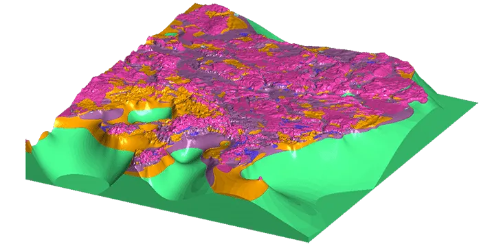
Soil Type Classifications
Quickly build 3D geological and numerical models from a wide variety of data sources, including borehole, structural, GIS, 2D grid, map, point, polyline, mesh/surface, historical cross-section data, geotechnical investigations, well screens, or points. Apply a range of modeling methods and powerful, intuitive interpolation controls. Perform structural modeling and use survey planning tools. Combine rock mass classifications, soil behavior, or contaminant concentrations with geological domains for combined soil type classifications.

Collaboration and sharing
Easily share cross-sections, images and videos, interactive 3D scenes, BIM, and CAD data output, improving not only productivity but also understanding.
Quickly visualize and share projects with Central for improved workflow and communication, enabling everyone from technical staff to non-technical stakeholders to understand what the data tells them.

Interoperability
Connect directly to the OpenGround Cloud platform to access your single source of geotechnical data. Easily import and export geotechnical and geoenvironmental data into specialized software packages, including GIS data from Esri geodatabases and shapefiles, Map Info, or raster imagery and maps. Easily export to industry-recognized BIM formats and publish directly into the BIM environment. Integrated with Autodesk's Drawing eXchange Format (DXF), Civil3D, and AutoCAD Drawing (DWG) formats.

Engineering projects
Don't wait for the CAD department to process your work, work directly with your engineering data in the geological context model. Quickly visualize and understand detailed tunnel designs, highway earthworks, bridges, dams, and building foundations in their geological context. Integrate designs, construct surface topography, and create excavation volumes to inform design. Import alignments and quickly create longitudinal sections.

Environmental insights
3D geological modeling simplifies the creation of geological and baseline values for groundwater flow simulation. Quickly assess contaminant plumes or saltwater intrusion by combining geologic models with water sample screenshots or geophysical data. Model directly from screenshots in AGS or gINT projects. Visualize plumes or saltwater wedge intrusions in 3D. Then, use the Hydrogeology Solution Kit to easily combine with flow models.

Generate cross sections
Create sections anywhere on your site in minutes, not hours. View from any angle, spin, rotate, and quickly detect errors. Work intuitively with tools that help you improve your analysis and identify correlations and trends. Update dynamically as your model evolves. Import cross-sections and historical maps. Customize output for reports, CAD, or geotechnical analysis.

Hydrogeological extension
Use this optional kit to incorporate MODFLOW and FEFLOW flow models to further reduce risk. Easily use lithology models as the basis for flow models to visualize modeling results. Import, create, and assign properties to MODFLOW and FEFLOW grids/meshes from your subsurface model. View the grids in a 3D scene and share your models with the free Leapfrog Viewer tools.

Contaminants extension
Bring contaminant data directly into your Leapfrog Works 3D geological models. This intuitive, interactive extension allows you to characterize, visualize, and create auditable estimates of contaminant mass and location in land and groundwater environments. Learn more.
System requirements
Important Notes / Unsupported Settings
- Running Leapfrog in a virtualized environment is supported; contact your regional support representative for more information.
- L’esecuzione di Leapfrog tramite una connessione desktop remoto o un altro sistema di accesso remoto non è supportata.
- Opening Leapfrog projects over a network connection is not supported.
- The graphics processor must have at least 4 GB of memory.
- Touchscreen hardware is not supported
| Minimo | Consigliato | |
|---|---|---|
| Sistema Operativo | Microsoft Windows (64-bit) 10, 11 | Microsoft Windows (64-bit) 11 |
| Processore | Intel Core i3, i5, i7 or i9 CPU (2nd Generation) or later,Intel Xeon, AMD FX or Ryzen | Intel Core i7-7700k, i7-8700k, i9-9900k |
| Memoria | 4 GB RAM | 32 GB RAM |
| DISCO | Hard Disk (HDD) 250 GB capacity, 25 GB free space | Solid-State (SSD) 1 TB or larger capacity, 100 GB free space |
| Display | 1920 x1080 | 2560 x 1440 |
Graphics requirements
| Minimo | Consigliato | |
|---|---|---|
| Nvidia - Desktop | GeForce 900, 1000, 1600, 2000 series, P series, RTX series | GeForce GTX 1050 / 1050 Ti, 1060, 1660 / 1660 Ti |
| Nvidia - Mobile | GeForce 1000, 1600, 2000 series, Quadro M series, P Mobile series, RTX series | GeForce GTX 1050 / 1050 Ti, 1060, 1660 / 1660 Ti |
| AMD - Desktop | RX, VII series, W series | Radeon RX 570, RX 590 |
| AMD - Mobile | RX series | RX 460 |
| Intel Integrated Graphics | N/A | N/A |